(Basic Geodesy Concepts 1)
Geoid – equipotential gravity surface, undulates, rises under a continent, deflection of the vertical, Everest trying to close a triangle in north India, at all points perpendicular with the direction of gravity, geoid height measured above/below geoid, NGS Geoid 99, Geoid 03, Geoid 06. At higher elevations equipotential surfaces are not parallel with those at sea level, they converge toward the poles. This requires an "orthometric correction" for leveling that has a large N-S component of coverage.
Orthometric height = elevation, symbol H, measured relative to a geoidal surface such as NGVD, NAVD88, or other surface. Ortho means "perpendicular" or "straight" -- For a point on a mountain top, the geoidal surfaces under it are not parallel. A vertical line along gravity is dropped from the point staying perpendicular with each geoidal surface until the sea level datum is reached. The length of this curving path is "elevation".
Ellipsoid – a regular surface formed by rotating an ellipse about its minor axis to approximate the shape of the earth. The earth is flattened by its rotation with a molten core. An ellipse has a major diameter and a minor diameter with "a" being the semi-major length and "b" being the semi-minor length. If a and b are more different, the ellipsoid is more "eccentric" or "flattened". There are over 100 ellipsoids used in the history of surveying. Some are "regional" -- the ellipsoidal surface matched the sea level geoid well in one continent but matches poorly other places. Others are "international" – of a shape that attempts to match all parts of the earth reasonably well.
A Geodetic Datum – a reference surface for horizontal positions – latitudes and longitudes (phi and lambda). To make a datum you must (1) choose an ellipsoid by picking a value for "a" and "b". (2) locate the ellipsoid's center relative to the earth's center of mass (3) orient the ellipsoid's minor axis (usually parallel with earth's spin axis) (4) choose the origin point, a point of measured or presumed lat and long on the ellipsoid (5) extend a survey and adjust values of a network on the ellipsoid.
For example; World Geodetic System of 1984 – WGS84 – this is the datum used by the GPS network. It uses the WSG84 ellipsoid, which is nearly identical in shape and orientation with the NAD83 ellipsoid. The "vertical" reading of a GPS receiver is NOT elevation, but an ellipsoidal or geodetic height, (symbol "h").
Geoidal Undulation (N) is the ellipsoidal height of the geoid relative to an ellipsoid. This value is given for each control station in the NGS database, see the data sheets. A negative value means that the geoid is under the ellipsoid.
GPS measures "geodetic height, h" the vertical distance above the ellipsoid of a chosen datum. To convert from GPS ellipsoidal height to geoidal height (orthometric height,elevation): h = H + N. Example: If N = -25 m, the geoid is 25 m below the ellipsoid. If GPS gives h = 100 m, then the elevation of the point H = h – N = 100 – (-25) = 125m.
(Basic Geodesy Concepts 2)
Difinition of Geodesy:
Definition of GEODESY
n Geodesy is the science of measuring and monitoring the size and shape of the Earth. (NOAA)
n the scientific discipline that deals with the measurement and representation of the Earth, including its gravitational field, in a three-dimensional time-varying space. (Wikipedia encyclopedia)
n Concerned with positioning and gravity field and geometrical aspects of temporal variations and also the study of the earth’s magnetic field.
Definition of GEODESY
Geodesy is the study of:
n The size and shape of the earth
n The measurement of the position and motion of points on the earth's surface
n The configuration and area of large portions of the earth's surface.
Geodesy serves as a foundation for the mapping and referencing of all geospatial data, it is a dynamic application of scientific methods in support of many professional, economic and scientific activities and functions, ranging from land titling to mineral exploration; from navigation, mapping and surveying to the use of remote sensing data for resource management; from the construction of dams and drains, to the interpretation of seismic disturbances.
Geodesy plays an active role in the geomatics industry that includes the disciplines of land surveying, photogrammetry, remote sensing, hydrography, cartography, engineering surveying, geographic information science, and geospatial computing.
(University of Melbourne)

Geoid & Reference Ellipsoid
n The geoid is essentially the figure of the Earth abstracted from its topographical features.
n It is an idealized equilibrium surface of sea water, the mean sea level surface in the absence of currents, air pressure variations etc. and continued under the continental masses.
n The geoid is irregular and too complicated to serve as the computational surface on which to solve geometrical problems.
n The geometrical separation between it and the reference ellipsoid is called the geoid undulation / geoid-ellipsoid separation. It varies globally between ±110 m.
n Ellipsoid – a regular surface formed by rotating an ellipse about its minor axis to approximate the shape of the earth.
n A reference ellipsoid is described by its semi-major axis (equatorial radius) a and flattening f. The quantity f = (a−b)/a, where b is the semi-minor axis (polar radius), is a purely geometrical one.
Geoid & Earth’s surface

Relationship between Surfaces

Relationship Between Different Surfaces

Earth:
An irregularly shaped planet we have to work on.
Geoid:
An equipotential surface (a fancy way of saying the pull of gravity is equal everywhere along the surface) which influences survey measurements and satellite orbits. A plumb bob always points perpendicular to the geoid, not to the center of the earth.
Ellipsoid:
An ellipse which has been rotated about an axis. This provides a mathematical surface on which we can perform our calculations. The shape of the ellipsoid is chosen to match the geoidal surface as closely as possible.
Coordinate Systems
n Astronomical Coordinates ( ɸA , ʎA )
n Spherical Geographical Coordinates ( ɸ, ʎ )
n Geodetic Ellipsoidal Coordinates ( Ø, ʎ, h )
n Cartesian Coordinates ( X, Y, Z )
n Geocentric Coordinate System

Cartesian Coordinates
local, possible arbitrary, z axis vertical throughout right handed system, bearings relative to y axis, ignores shape of earth, x,y,z
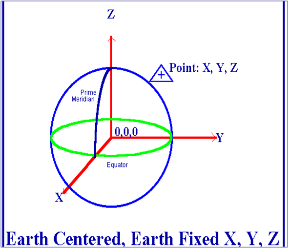
Geocentric Datum
A geocentric datum is a system with origin (0,0,0) that coincides with the center of the mass earth and the directions of their axes are defined by the IERS spin axis as Z-axis, X-axis is the direction of the IRM and Y-axis is perpendicular to both of these.

Geodetic Ellipsoidal Coordinates ( Ø, ʎ, h)
• The geodetic latitude of a point is the angle from the equatorial plane to the vertical direction of a line normal to the reference ellipsoid.
• The geodetic longitude of a point is the angle between a reference plane and a plane passing through the point, both planes being perpendicular to the equatorial plane.
• The geodetic height at a point is the distance from the reference ellipsoid to the point in a direction normal to the ellipsoid.

Spherical Geographical Coordinates ( ɸ, ʎ )
The most commonly used coordinate system today is the latitude, longitude, and height system. The Prime Meridian and the Equator are the reference planes used to define latitude and longitude.
traverse ape...mcm mane ia boleh digunakan utk mninngkatkan ketepatan point positioning..
ReplyDeleteTraverse ni yalah sejenis biskut yang boleh dimakan dengan sos. Sos apa kau pilih, tu kau punya hal lah. haha
ReplyDelete